Administrative District Map
-
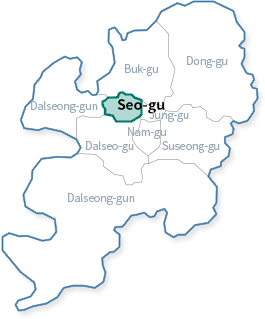 District Map of Daegu Metropolitan City
-
 District Map of Seo-gu
Location
- Location of Gu Office : 257 Gukchaebosangno(Pyeongri 3-dong 1230-9), Seo-gu, Daegu, Republic of Korea
- Longitude Latitude Pole
Longitude polarized table consisting of End, Name of Place, East Longitude, and North Latitude. End Name of Place East Longitude North Latitude Eastern End 81, Wondae-ro 128˚ 35′04″ 35˚ 52′55″ Western End San276-2, Sangni-dong 128˚ 31′08″ 35˚ 52′47″ Southern End 8, Dalgubeol-daero 337-gil 128˚ 33′08″ 35˚ 51′08″ Northern End 2117, Bisan-7dong 128˚ 33′11″ 35˚ 52′48″
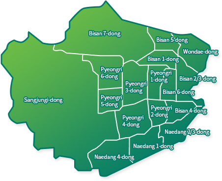
Area
- Area by Dong (District)
A table of western eastern areas consisting of Classification, Area (km2), Compositional Ratio (%), Tong, Ban, Administrative District, and Court District. Classification Area(㎢) Composition Ratio(%) Tong Ban Administrative District Court District The Entire 17.33 100 337 2,360 17 9 Naedang1-dong 0.47 2.71 18 120 1 1 Naedang2,3-dong 0.65 3.75 20 146 1 Naedang4-dong 0.76 4.39 30 179 1 Bisan1-dong 0.64 3.69 19 139 1 1 Bisan2,3-dong 0.49 2.83 22 160 1 Bisan4-dong 0.39 2.25 18 135 1 Bisan5-dong 0.28 1.62 14 102 1 Bisan6-dong 0.27 1.56 13 99 1 Bisan7-dong 2.74 15.80 23 173 1 Pyeongri1-dong 0.39 2.24 16 110 1 1 Pyeongri2-dong 0.29 1.67 12 87 1 Pyeongri3-dong 0.78 4.49 24 161 1 Pyeongri4-dong 0.74 4.26 27 184 1 Pyeongri5-dong 0.42 2.42 14 97 1 Pyeongri6-dong 0.73 4.20 17 121 1 SangJungi-dong 6.69 38.55 30 209 1 3
(Sangli, Jungli, Ihyeon)Wondae-dong 0.60 3.57 20 138 1 3
(Wondae1,2,3-ga)